
Everen T. Brown's mission statement is simple: "Everen T. Brown photographs all that he sees, for life is meant to be lived in 360 degrees". Everen's travels have taken him over one million and a half miles — to all seven continents and both poles. In the process, he has created the world's largest collection of 360° images.
His VR Images (for virtual reality) have been featured in Microsoft's Encarta Encyclopedia, on the Expedia website, and in the Grolier Multimedia Encyclopedia. His print images have appeared in a variety of magazines worldwide and in selected exhibitions. He is the photographer and author of four books highlighting his unique imagery, Panoramic World, Circumnavigation Antarctica, History's Lost Cities, and 7-360°. His work was featured prominently in the book and on the cover of Stretch: The World of Panoramic Photography by Nick Meers.
Named by the International Association of Panoramic Photographers as "Member of the Year", he has also won awards for his images, most in the landscape category. The American Red Cross honored him for his work on the World Trade Center Panoramic Poster Project, which raised funds for the survivors of 9/11.
The 360° World Atlas is his dream project, utilizing his best images from his travels all in a single collection!
CIRCUMNAVIGATION AUSTRALIA
In my quest to Circumnavigate the Continents, Australia has been the easiest by far! Twenty eight days onboard a luxury cruise liner, working my way around the island continent, visiting some of Australia's best known destinations. From sleepy Broome - with its picturesque Gantheaume Point to sunny Rottnest Island, I have added some great 360° images to the Atlas project. Despite the temptation of never-ending buffets and non-stop shows, I survived this 9,581 mile cruise.

TAPATI RAPA NUI FESTIVAL
My dream of attending the Tapati Rapa Nui Festival on Easter Island was realized this February. The island came alive with a variety of events, both cultural and sporting. From the unique Rapa Nui Triathlon held at Rano Raraku, to nightly singing and dancing performances in Hanga Roa, it was a great opportunity to see the islanders at their best. The trip was extra special, as several fans of the 360° World Atlas joined me for a behind-the-scenes photo shoot. Everyone had such a great time we are offering this trip again next year.

I have always been entranced by traveling around the world, going in one direction, always traveling forward and never looking back. The routings for this type of trip always put me in a variety of unusual places, perfect to capture images for the 360° World Atlas project. This global odyssey covered 13 countries: Western Samoa, American Samoa, New Zealand, Australia, South Africa, Uganda, Rwanda, Egypt, Lebanon, Istanbul, Switzerland, Kazakhstan, and Russia. Highlights included: ancient ruins of Lebanon, Gorilla trekking in Uganda and Rwanda, Launch of the Soyuz rocket to the international space station, Wave Rock and the Pinnacles of Western Australia. Minor disappointment in Switzerland — the world famous Matterhorn was enshrouded in clouds, despite my patient three day vigil to acquire this signature image. This trip covered 31,129 miles, 48 days, and 24 time zones!

EASTER ISLAND ECLIPSE
Eclipse chasers from around the world traveled to remote Easter Island for a total solar eclipse on July 11, 2010. Preparations for this trip began two years before, as the limited hotel space and flights to Easter Island would dictate who would be lucky enough to get there for this solar phenomenon. My base was near Tahai, with its scenic Moai statues located next to the ocean. My goal: to create a transition VR image before and during totality for the Atlas. Getting up extra early I secured my spot and began my nine hour wait for this show in the sky? The photo turned out as planned, and will be in the 360° World Atlas Global Edition. I also enjoyed the opportunity to have plenty of time before and after to tour the island and create iconic panoramic images of the Moai.

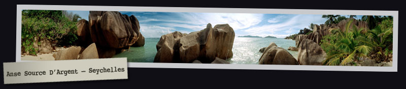
THE SEYCHELLES
A life long dream was realized with a trip to Seychelles, just off the west coast of Africa. Boulder strewn beaches provided the backdrop for some of my most favorite 360° Images yet! I spent so much time photographing the amazing scenery; I didn't get a chance to really enjoy the world renowned beaches. Perhaps another time?
DUBAI, QATAR, AND BAHRAIN
A race is going in the Middle East to see which country can out build the others. Legions of construction workers, along with giant cranes, are building "cities of the future" on land reclaimed from the sea. If you search long enough — you can still find remnants of the historic old city quarters!

RIO DE JANEIRO — CARNAVAL
Once a year Rio de Janeiro goes all out for Carnaval, with parades that start at 8 p.m. and continue through the night, ending only when the sun comes up! The Samba schools do their best to compete at the world famous Sambadrome, dancing and marching their way to prove they are the best. The winners get bragging rights for a whole year! Street parties break out all across the city and it is indeed one the best times to visit this city by the sea.

TIMBUKTU, MALI
Yes, Timbuktu really exists. This small town, near the center of Mali, has been the crossroads of West Africa for centuries. Its new international airport now serves travelers from every continent. Scholars visit the world-famous library, housing a precious collection of over 100,000 historic manuscripts. Tourists visit the mosques and other ancient structures and hunt for Timbuktu T-shirts to prove they actually made the journey to this mythical destination.
I am overwhelmed by Timbuktu's mud buildings, which provide intriguing shapes for my 360º images. The central core of the city is tightly knit and challenges me to tell its story photographically.

YIWU, CHINA
On August 1, 2008, this city in China's northwest corner became "Eclipse City". Thousands from around the world converged on a special viewing site erected by the government to see the total solar eclipse. Taking extra pride in the event, the Chinese built an observatory and created a mini-museum dedicated to the planets and astronomy. Tickets to the site were sold for $100 US, which was funny, as you don't need a ticket to view an eclipse. Later, I learned the fee was for the security forces, which swarmed the region to protect eclipse chasers.

Viewing and photographing an eclipse often comes down to luck. Even when you've done your homework, identified the best possible location, and tracked potential weather conditions, last minute cloud cover can spoil it all. I was in position — four Globuscopes loaded with film and ready to go. With five minutes to totality, clouds obscured the sun, and I prepared myself to miss the most important part of the eclipse. Would the clouds move fast enough to bring the sun back into view? With less than two minutes to go, the clouds parted just enough. My patience was rewarded with an incredible 360° image showing the sun high in the sky with the moon in front of it. Totality at last!
This image will be included in the 360° World Atlas in "transition VR" mode. The VR will transition every fifteen seconds between the two images, revealing the scene both before and during totality. This is only the second time I have created such a 360º image during an eclipse. With a little more luck, I plan to continue the series at the next total solar eclipse on July 22, 2009.
CAPE YORK, GREENLAND
Aboard the Russian icebreaker, Kapitan Khlebnikov, I returned to the northeast side of Greenland to continue documenting this endangered part of the world. No polar bears on this trip, but a chance to seewalrus in the wild — what an adventure!

One of the unexpected highlights of the trip was a visit to an amazing monument at Cape York. This 60-foot memorial, built in the 1930s and dedicated to the American polar explorer, Admiral Robert Peary, sits atop a remote mountain. The only way to get there easily is by helicopter — a method of transportation not available to either Peary or the builders of his monument. I can only imagine the work involved to construct it in these harsh conditions. The plaque also pays tribute to the polar Inuit of Greenland, who helped Peary on his expeditions, but begs the question: Who will visit it? I did and was grateful for the striking 360° vista, overlooking a glacier with icebergs in the distance.
Etah Glacier, Greenland, was another great destination with perfect weather. Then it was on to Canada with stops at Fort Conger and Baffin Island, to capture more amazing sights in the polar north for the 360º World Atlas.

In 1981, the Globuscope camera was introduced. Developed by the Globus Brothers of New York City, it was the world's first hand-held 360° rotational camera. Weighing in at only 3.5 lbs. it was also one of the most portable panoramic cameras ever invented.
This 35mm film camera allows a photographer to capture eight 360° images on a single roll of 36-exposure film. Each 360° negative measures 6.25 inches in length. For many years, the negatives from this camera could be blown up to 12 feet long to create spectacular prints. Now these negatives can be scanned on Hasselblad Flextight scanners, with up to 3800% magnification, for use in a variety of print and digital media.
With the advent of Virtual Reality software, Globuscope imagery found a new platform. Rotating 360° within one second, the camera easily captures images other cameras cannot. The result is a high-resolution image on film. Software programming then allows a user to "sew" the ends of the 360° image together to create a rotating panoramic "movie" often referred to as a VR (for virtual reality). These interactive VR images make up the 360° World Atlas!
After 25 successful years, the Globuscope is no longer in production. Everen owns four of these remarkable cameras and will continue to use them until the next generation of high-resolution/high-speed cameras finally meets or exceeds the Globuscope's capabilities.
KSL-TV NEWS – Dec. 2009 – Reported by John Hollenhorst
Brown has developed an electronic world atlas that gives armchair travelers a virtual tour of the Earth, in the round. It's main feature is a catalog of panoramic photos he's taken while crisscrossing the globe, visiting some of Earth's most exotic and scenic places.
Read more and see video at KSL.com
AIR CANADA'S ENROUTE MAGAZINE – October 2008 This brand-new DVD atlas features image-based tours by the travel photographer Everen T. Brown, taken with a now discontinued Globuscope camera that rotates through a full circle to create a panoramic 360-degree image. The DVD contains over 1,200 tours, searchable by continent, country and region, and is supplemented with historic and geographic information. You can even use the Interactive Passport to track countries you've already visited when your own travel journal just won't cut it.
DISCOVER MAGAZINE – Sept. 200 – from "Around the World in 360 Degrees by Boonsri Dickinson" The 360° World Atlas DVD lets anyone with a computer become a virtual hitchhiker, no packing or neck-craning required. Creator Everen Brown does all of the hard work for you. He jets around the globe, lugging a 40-pound bag full of 600 rolls of film past airport security, and picks a picture-worthy spot. Then he takes one of the world's last Globuscope rotational cameras (no longer in production), holds it over his head (sometimes he lies on his stomach), and waits (sometimes for hours) for the right shot. When he sees it, snapping the picture takes only a second. The lens rotates full circle, so you get to see what's across from the Taj Mahal's minarets too. Once Brown develops the film, he embeds the images into an interactive atlas that shows off head-turning views, panorama style.
POPULAR PHOTOGRAPHY – Sept. 2008 from "Whirled Tour by John Owens" While most photographers can shoot from the edge of a scene, the Globuscope requires, as Brown puts it, "total immersion." He goes into the Grand Canyon. Into Peru's Machu Picchu. Into the heart of Britain's Stonehenge. "I am always looking for that center spot," he says. "I have to get into the middle of the action."
NATIONAL GEOGRAPHIC ADVENTURE MAGAZINE – April 2008 from "Around the World – A Traveler's Digital Atlas of Obsession by Ryan Bradley" Unlike the grainy, fish-eye shots offered by Google Maps' Streetview feature, Brown's vision is more discerning – and much farther flung. The 360° World Atlas contains 1,200 of his finest panoramas, looking beyond London, Paris and Rome to include the likes of Kamchatka, Timbuktu, and Yankich Island – a stormy primordial slab of rock north of Japan and south of Russia that Brown calls "heaven on Earth." His affinity for such unusual places is what first inspired this project and has since helped him turn his travels from a hobby into a full-time obsession.
Everen T. Brown is available for presentations — from Keynotes, Lectures to Workshops. Topics cover the 360° World Atlas project, "Things Learned En-route" and other interesting topics geared to your audience. Each presentation is highlighted with a "Whirl around the World", as Everen shares some of his favorite images 360° Images on the Big Screen! Learn more about booking Everen for your next event — phone (801) 364-2642 today.